The intersection of blight in downtown Federal Way | PHOTOS
Published 4:59 pm Tuesday, April 30, 2013
Federal Way’s so-called downtown core brimmed with potential before the recession froze the U.S. economy.
A prime illustration of the recession’s effect on Federal Way can be seen at the intersection of 20th Avenue South and South 316th Street. Today, all four corners are plagued by garbage, graffiti, abandoned buildings and vacant lots.
On the southeast corner, crews demolished the AMC Theatres in 2007 to make way for a string of failed proposals that included skyscrapers and a “crystal palace.” The latest proposal under consideration is a park with a “town square” surrounded by private businesses and residences. The city owns this 4-acre site.
On the northeast corner is the former Toys R Us, which closed in 2006, alongside another decaying building that once housed Target. The 4-acre site is slated for a $32 million performing arts and conference center (PACC) with a hotel. City leaders hope the 700-seat PACC, if it’s built, will transform the downtown area and act as a catalyst for development. Also on this side of the street is a half-full strip mall with a few busy tenants such as 24 Hour Fitness and Gene Juarez Academy of Beauty.
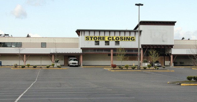
On the northwest corner is the former Top Food and Drug, which shut its doors this spring, less than two years after the neighboring Walmart was remodeled and began selling groceries. Also on this corner is the Palace Korean Bar and Grill, which is still open for business.
On the southwest corner is the Clarion Hotel with 115 rooms, with a 117-room Comfort Inn tucked behind it. Both hotels keep well-groomed sites. However, the hotels border another vacant lot that’s riddled with litter and makeshift campsites for the homeless. From 20th Avenue South, pedestrians can access the vacant lot from a staircase marred in trash and broken glass.

(Pictured: A homeless campsite located under some trees behind the Comfort Inn and Clarion Hotel.)
In 2006, Woodstone Credit Union opened a new headquarters on South 316th Street, next to the Clarion. CEO Susan Streifel recalled the confidence and demand that dovetailed with investing in that part of the city. The Federal Way Transit Center opened in February 2006, and at the time, city leaders projected a clear vision for developing the area.
“We made a conscious decision to be in the core of the city,” said Streifel, adding that Woodstone’s previous Federal Way headquarters had opened in 1988 at 1st Avenue South and South 336th Street. She believes the area surrounding the credit union’s current location would have a different story to tell if not for the recession that took hold in 2008.
In 2013, she is looking for one specific indicator that Federal Way’s downtown core is moving forward once again.
“I want to see some people with shovels and hardhats,” she said. “I’ll know we’re on our way when we see that.”
As the economy recovers, city leaders continue to entertain proposals in hopes of stimulating downtown development.
“Whatever we do, it must fulfill specific criteria,” said Mayor Skip Priest in his 2013 state of the city speech. “It must be affordable to build, it must be affordable to operate, and it must be big enough to create the kind of change the downtown needs. Nothing against senior housing, or a strip mall, but if that’s what ends up on these sites, we will have wasted a lot of time and we will have lost ground in the process.”

(Pictured: On Tuesday, a father took his son for a driving lesson in the empty parking lot where the vacant Toys R Us building is located on 20th Avenue South.)
Traffic count
The closure of Top Food and Drug will likely affect the number of vehicles that travel through that area of Federal Way.
The city’s website has posted maps that illustrate the average daily traffic (ADT) for Federal Way streets. Maps from August 2006 and August 2010 both show that South 316th Street and 20th Avenue South each attracted 5,000 to 15,000 weekday vehicles. The most heavily-traveled roads, according to both maps, received more than 35,000 vehicles a day:
• South 320th Street between I-5 and Pacific Highway South (note: the 2006 map shows this level of traffic extending to 1st Avenue South)
• South 348th Street between Pacific Highway South and SR 18
• Pacific Highway South, specifically the stretch between South 304th Street and the northern edge of the city

(Pictured: A bench near Top Food and Drug that faces South 316th Street in Federal Way.)
For photos of businesses and blight in this area of Federal Way, see the slideshow below or click here.