A section of Southwest Dash Point Road will remain closed until mid-week after a mudslide damaged about 120 feet of street in the 2800 block early Thursday morning.
The road is closed from approximately 26th Place Southwest to 3oth Avenue South. It will likely reopen Wednesday, Mayor Jim Ferrell said.
Ferrell declared a state of emergency after surveying the area with city employees later that morning. By declaring a state of emergency, which allows the city to bypass the public bidding process it would normally follow, thus expediting the repair process.
“This declaration will allow us to immediately address this issue without delay for purposes of contract bidding and material acquisition,” Ferrell said. “It will also make us eligible for future state or federal grant funding, if certain criteria are met for his storm event.”
Ferrell said he learned of the mudslide after Police Chief Andy Hwang called to tell him the road was being closed. He said the magnitude of the mudslide that covered between 100 and 120 feet of road was astonishing. Several safety barriers lining the road, some of which that were linked, were either moved and damaged. Ferrell said it was astounding how far those barriers were moved — across the roadway and over the Lakota Creek embankment.
“First of all, you would not believe the force involved,” he said. “Some of those barriers weigh several thousand pounds, and it literally lifted a barrier at least 15 to 20 feet across the road and up an embankment at least 10 feet. The amount of force to do that was really staggering.”
City crews removed the mud and debris from the road after a geotechnical engineer determined the area was safe. Lakehaven Utility District, which has a nearby wastewater treatment plant, provided city staff with trucks to help clear the mud and debris, and Puget Sound Energy’s tree service removed hazardous trees in the area to prevent them from falling into overhead power lines.
Ferrell said the road remains closed, however, while the safety barriers are either replaced or moved for the safety of drivers and it is determined whether the underlying roadway is safe for use.
While the mudslide destroyed concrete barriers and covered the roadway with small river of mud and debris, Lakota Creek was not blocked and did not affect the Lake Haven wastewater treatment plant operations, although the facility had to run off of a generator after losing power for a while, Ferrell said. The creek also did not appear to sustain major damage, although mudslide debris that crossed the road destroyed some of the embankment and caused soil to slough into the creek. Ferrell said, however, according to Public Works Director Marwan Salloum, approximately two feet of road on the Lakota Creek side was lost. The city will have to receive permission from the State Department of Fisheries in order to reconstruct and replace the barriers because of the proximity to the creek.
Ferrell said, while Southwest Dash Point Road is well-traveled and the area surrounded by several hundred residences, fortunately no one was on the roadway at the time of the mudslide.
“If anybody was driving through at that time it would have been an unfortunate situation,” he said.
Ferrell said, while there have been small mudslides through the years, nothing like this has happened since he joined the council. He said it was caused by the “historic amount” of rainfall the area has experienced.
According to mynorthwest.com, March 15, between March 7 and March 13, the Pacific Northwest has received 200 to 600 percent of its normal rainfall, reported Cliff Mass, a professor of atmospheric sciences at the University of Washington.
Accuweather.com also posted a landslide warning more much of this area, including Federal Way because “persistent wet weather has kept soils in Western Washington near saturation, causing [U.S. Geological Survey] landslide thresholds to be exceeded.”
“Additional rainfall will put extra pressure on soil instability, leading to an increased threat of landslides,” according to the website.
To see a map of the detour route established following the road closure, visit www.cityoffederalway.com/page/public-works-department, and click on the detour map link.
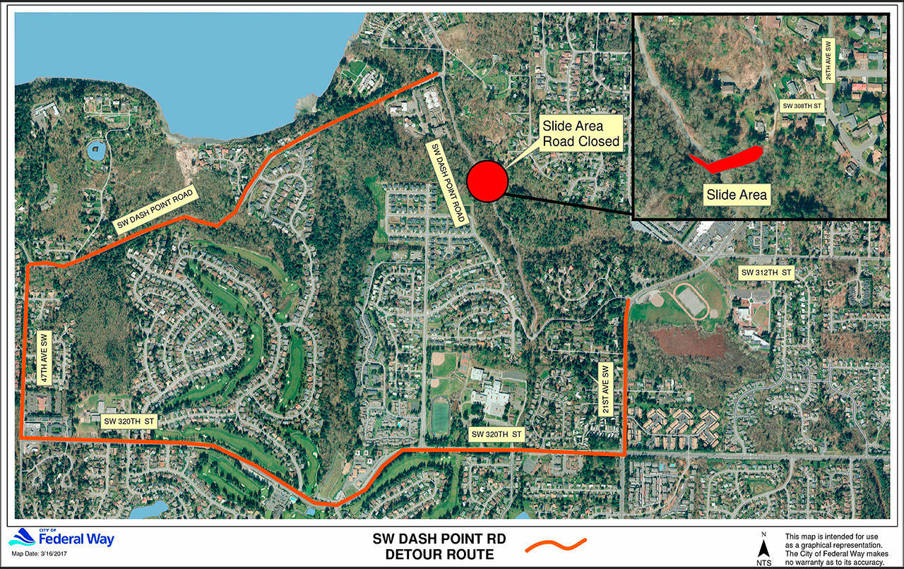
This graphic shows the detour route people can follow after a mudslide damaged a section of Southwest Dash Point Road in Federal Way early Thursday morning. The detour route takes drivers down Southwest Dash Point Road to 47th Avenue Southwest and around to Southwest 320th Street to 21st Avenue Southwest. The road is not likely to reopen until Wednesday.

This graphic shows the detour route people can follow after a mudslide damaged a section of Southwest Dash Point Road in Federal Way early Thursday morning. The detour route takes drivers down Southwest Dash Point Road to 47th Avenue Southwest and around to Southwest 320th Street to 21st Avenue Southwest. The road is not likely to reopen until Wednesday.